Are you tired of relying on technology to find your way around? Do you want to learn how to navigate using your natural instincts and surroundings? In this article, you’ll discover some useful tips and tricks on how to navigate without a GPS or compass. Whether you’re an avid adventurer or simply want to enhance your survival skills, you’ll find this information helpful and fascinating.
In the upcoming paragraphs, you’ll explore alternative methods for finding your way when you don’t have access to a GPS or compass. From using natural landmarks like the sun and stars to reading the signs provided by nature, you’ll learn how to tap into your surroundings as a navigational guide. Additionally, we’ll delve into the importance of developing a keen sense of observation and how to use tools such as a map and analog watch to determine your direction accurately. So, let’s dig in and empower ourselves with the knowledge of navigating without relying solely on technology.
Understanding the Basics of Navigation
Importance of Navigation Skills
When it comes to exploring the great outdoors, navigation skills are essential. Whether you’re hiking in the mountains, sailing across the ocean, or simply trying to find your way in unfamiliar territory, understanding the basics of navigation can be a lifesaver. In today’s digital age, we heavily rely on GPS devices and compasses to guide us, but what if you find yourself without these modern tools? This article will provide you with a roadmap on how to navigate without a GPS or compass, using natural techniques and traditional knowledge.
Using Landmarks
One of the first steps in navigating without a GPS or compass is learning how to use landmarks. Landmarks are recognizable features in the environment that can help you orient yourself and determine your location. They can be natural, such as mountains, rivers, or distinctive rock formations, or man-made, such as buildings or roads. By identifying and remembering these landmarks, you can create a mental map of your surroundings and easily find your way back.
Getting Familiar with Cardinal Directions
Understanding cardinal directions is another crucial skill for navigation. Cardinal directions refer to the four main points on a compass: north, south, east, and west. By familiarizing yourself with these directions, you can determine which way you are heading and navigate accordingly. There are several ways to determine cardinal directions without a compass. For example, moss usually grows on the north side of trees in the northern hemisphere. Additionally, the sun rises in the east and sets in the west, providing a reliable reference point for determining direction.
Using the Sun as a Guide
The sun is a powerful natural navigation tool that can help you find your way. When the sun is visible, it can provide you with a sense of direction. In the northern hemisphere, the sun is generally in the southern part of the sky, so if you are facing the sun, you know you are heading south. Similarly, if it’s early morning and the sun is on your right, you are heading east. By observing the position of the sun throughout the day, you can maintain a general sense of direction.
Using Natural Navigation Techniques
Observing the Stars
Stargazing isn’t just a hobby for astronomers; it can also be a useful navigation technique. The stars have guided sailors and explorers for centuries. By familiarizing yourself with different constellations and their positions in the sky, you can determine your latitude and even estimate your approximate longitude. The North Star, also known as Polaris, is particularly helpful for navigation in the northern hemisphere. It remains almost stationary, almost aligned with the Earth’s axis, making it a reliable reference point.
Tracking the Moon’s Path
The moon’s path across the sky can also provide valuable navigation information. The moon rises in the east and sets in the west, like the sun. However, its path across the sky changes throughout the month. By observing the moon’s position at different times of the night, you can determine your approximate direction. For example, if the moon rises on your left side, you are likely facing north.
Navigating with the Help of Constellations
In addition to individual stars, constellations can serve as navigational guides. Constellations are groups of stars that form recognizable patterns in the night sky. Various cultures have developed their own stories and legends around these patterns, making them easier to remember and recognize. By learning a few key constellations and their positions during different seasons, you can navigate using the stars as your guide.
Utilizing Natural Features
Nature provides us with a multitude of navigational clues if we know how to interpret them. For example, rivers and streams often flow towards the nearest body of water, such as a lake or ocean. By following the flow of water, you can determine the general direction you should travel. Mountains and ridges can also act as barriers or landmarks, helping you stay on course or avoid getting lost. Additionally, observing the behavior of birds and animals can provide valuable information about weather patterns and potential hazards.
This image is property of i0.wp.com.
Navigating through Terrain and Topography
Reading Topographic Maps
Topographic maps are detailed representations of the Earth’s surface, showing elevations, contours, and other geographical features. Learning how to read these maps can greatly enhance your navigation skills. Contour lines, for example, represent changes in elevation and can help you understand the terrain you’ll be navigating. By carefully examining the map and understanding its symbols and legends, you can plan your route and estimate the difficulty of the terrain.
Understanding Contour Lines
Contour lines are an essential part of topographic maps and can provide crucial information for navigation. These lines connect points of equal elevation, forming curves on the map. By studying the spacing and shape of contour lines, you can identify valleys, mountains, and other features. If contour lines are close together, it indicates a steep slope, while spread-out lines suggest a more gradual incline.
Estimating Distance and Scale
Another important aspect of navigation is estimating distance and scale. Topographic maps usually include a scale bar that represents a specific distance on the ground. By using this scale bar, you can calculate distances between points on the map and plan your route accordingly. Additionally, by estimating the time it takes you to cover a certain distance, you can create a rough schedule for your journey.
Analyzing Elevation Changes
Understanding elevation changes is crucial for navigation, especially in mountainous terrain. By analyzing the contour lines on a topographic map, you can anticipate steep inclines, descents, and potential obstacles. This information allows you to plan your route and make informed decisions about the energy and time required to complete your journey. Additionally, understanding elevation changes can help you avoid hazardous terrain or choose the best path to follow.
Mastering Dead Reckoning
Choosing a Starting Point
Dead reckoning is a method of navigation that involves estimating your current position based on your previously known position, course, and speed. To utilize dead reckoning effectively, you must establish a starting point with a known reference point or landmark. This could be a distinctive tree, a rock formation, or any other feature that stands out in the landscape. By plotting this starting point on a map or keeping it in mind, you can then navigate by estimating distances and directions from this point.
Keeping Track of Distance and Direction
Dead reckoning requires accurately tracking your distance and direction of travel. Understanding pacing and measuring your steps can help you estimate distances on the ground. By counting your steps and knowing your average step length, you can calculate how far you have traveled. Additionally, using natural features, such as rivers or ridges, can help you maintain a consistent direction of travel, providing valuable reference points along the way.
Using Landmarks and Landforms
Throughout your journey, it’s essential to keep an eye out for landmarks and landforms that can assist you in maintaining the correct course. These can include mountains, valleys, lakes, or any other distinctive features you identified before starting your journey. By periodically checking these landmarks against your map or mental image, you can ensure that you’re staying on track.
Adjusting for Wind and Current
Dead reckoning requires constant adjustments to account for variables such as wind and current. Strong winds, for example, can push you off course, especially if you’re traveling across open terrain. By accounting for these factors and adjusting your estimated distance and direction accordingly, you can maintain a more accurate position and prevent getting off course.

This image is property of nature-mentor.com.
Orienting Yourself Using Nature’s Clues
Reading the Sky and Cloud Formations
The sky and its formations can provide valuable information about the weather and your current location. Clouds can indicate weather patterns and approaching storms, helping you make informed decisions about your journey. Sunrises and sunsets can provide a general sense of direction, while the color of the sky can indicate changes in weather conditions. Paying attention to these clues can enhance your navigation skills and keep you safe while exploring.
Noticing Wind Patterns
Wind patterns can also provide valuable information about your location and direction. In coastal areas, for example, prevailing winds often blow from specific directions. By observing the direction the wind is blowing from, you can determine your approximate position relative to the shore. Similarly, in open terrain, you can use the direction of the wind to your advantage. For example, if you’re traveling upwind, you can expect to encounter obstacles or natural features sooner.
Finding Direction Using Trees and Plants
Trees and plants can also serve as natural compasses, providing clues about direction. For example, in the northern hemisphere, tree branches tend to grow more densely on the south side of trees. By observing the density and shape of tree growth, you can estimate which direction is south. Additionally, some plants, such as sunflowers, have been known to face east during the day, tracking the movement of the sun.
Paying Attention to Animal Behavior
Animals have a keen sense of direction and often exhibit specific behaviors when it comes to migration and finding food sources. Watching the behavior of birds and other wildlife can provide valuable information about your surroundings. For example, birds flying in a specific direction can indicate the presence of a water source or the proximity of land. Similarly, following the movement patterns of migrating animals can lead you to areas with abundant resources.
Learning Navigation Techniques from Indigenous Cultures
Studying Traditional Indigenous Knowledge
Indigenous cultures have relied on traditional navigation techniques for centuries, developing sophisticated systems to navigate the land and sea. By studying the navigation methods used by indigenous peoples, you can gain a deeper understanding of the natural world and learn alternative ways to navigate without modern tools. Indigenous knowledge often involves a deep connection with the environment and a profound understanding of natural cycles and patterns.
Understanding Celestial Navigation Methods
Celestial navigation, also known as astronavigation, is a technique that uses celestial bodies, such as the sun, moon, stars, and planets, to determine position and direction. Indigenous cultures from around the world have developed their own celestial navigation methods, often incorporating intricate observations and interpretations of celestial movements. By learning these methods, you can navigate using the positions of celestial bodies as your guide.
Exploring Ancient Wayfinding Techniques
Ancient cultures have developed various wayfinding techniques that rely on natural navigation cues. These techniques often involve observing the environment, such as changes in waves, wind direction, and the behavior of marine life. By carefully interpreting these cues, ancient navigators were able to accurately reach their destinations. Exploring these ancient techniques can provide you with alternative approaches to navigation and deepen your understanding of the natural world.
Adapting Traditional Methods to Modern Navigation
While traditional navigation techniques may have been developed in a different era, many of their principles can still be applied today. By adapting traditional methods to modern navigation tools, you can enhance your skills and broaden your knowledge of navigation. For example, using a combination of traditional celestial observations and digital mapping technology can provide a more accurate and holistic understanding of your position and direction.
This image is property of azweaponcraftprepper.files.wordpress.com.
Using Basic Tools for Navigation
Creating a Simple Compass
In situations where a compass is unavailable, you can create a simple navigational tool using basic materials. One method involves rubbing a needle against a piece of magnetized material, such as a lodestone or a magnet. This process aligns the needle with the Earth’s magnetic field, allowing you to determine the north-south direction. By floating the needle on a piece of paper or a leaf in water, it will point towards magnetic north, providing a makeshift compass.
Making a Sundial
A sundial is a timekeeping device that uses the position of the sun to indicate the time of day. While not suitable for precise navigation, a sundial can give you a general sense of direction and help you estimate the time. To create a simple sundial, you’ll need a stick or rod placed vertically in the ground. As the sun moves across the sky, the shadow cast by the stick will change position, indicating the passage of time.
Using a Watch as a Navigation Tool
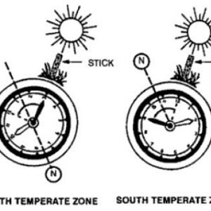
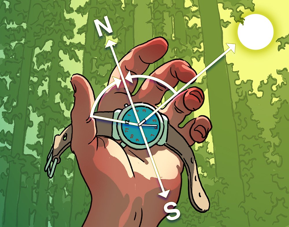
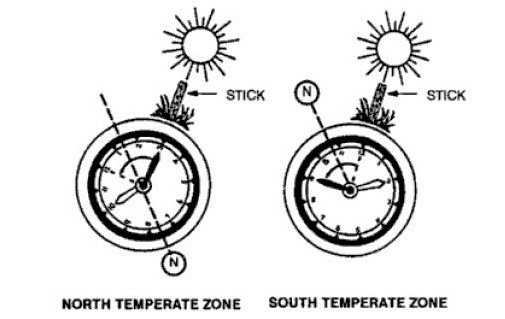
Watches can also be used as basic navigation tools. By aligning the hour hand with the sun, you can determine the approximate north-south direction. In the northern hemisphere, halfway between the current hour and 12 o’clock points to the south. In the southern hemisphere, the halfway point between the hour hand and 12 o’clock indicates the north. By using your watch as an improvised compass, you can navigate even without a dedicated navigation device.
Building and Using a Water Bottle Sextant
A sextant is a navigational instrument used to measure the angle between celestial bodies and the horizon. While building a traditional sextant may not be feasible without proper tools and materials, you can create a makeshift version using a water bottle. By filling the bottle with water and carefully aligning it with celestial bodies, you can estimate the angle between the body and the horizon. This information, along with the time and date, can help you determine your latitude.
Developing Orientation Skills in Different Environments
Navigating in Forests and Woodlands
Navigating in dense forests and woodlands can be challenging due to limited visibility and the abundance of similar-looking features. To navigate effectively in these environments, it’s crucial to constantly observe and remember distinct landmarks. By choosing reference points that are visible from multiple directions, such as mountaintops or unique rock formations, you can create a mental map of your surroundings. Additionally, maintaining a sense of direction by using the sun or other natural cues can prevent you from becoming disoriented.
Orientation Techniques for Deserts
Deserts pose their own unique challenges when it comes to navigation. The vast, seemingly featureless landscapes can easily disorient even experienced navigators. In these environments, it’s essential to rely on cardinal directions, the position of the sun, and natural features such as sand dunes or rock formations. Additionally, keeping track of your steps and using pacing to estimate distances can help you navigate through the seemingly endless desert.
Navigation Skills in Mountainous Terrain
Navigating in mountainous terrain requires a combination of skills, including reading topographic maps, understanding contour lines, and using natural features as landmarks. Mountains often provide clear visibility, allowing you to locate distant landmarks and maintain a sense of direction. However, it’s important to consider elevation changes and potential hazards, such as steep slopes or cliffs. By plotting your route and regularly checking your position against the map and the surrounding terrain, you can navigate safely and efficiently in the mountains.
Finding Your Way at Sea
Navigation at sea presents a unique set of challenges, as there are often no visible landmarks or reference points. In these situations, celestial navigation, using stars, the sun, and the moon, becomes particularly important. Understanding the principles of celestial navigation and maintaining accurate timekeeping are essential for determining your position and direction on the open water. Additionally, using tools like a compass, nautical charts, and navigational aids can provide valuable guidance and ensure a safe voyage.
This image is property of cdn.hiconsumption.com.
Building Experience and Confidence
Practicing Navigation in Controlled Environments
Before venturing into unfamiliar or challenging landscapes, it’s essential to practice and build confidence in your navigation skills. Start by exploring local parks or nature reserves that offer controlled environments for navigation. Familiarize yourself with the terrain, landmarks, and features, and practice using your navigation techniques. By gradually increasing the complexity of your navigation exercises, you can gain experience and prepare for more demanding journeys.
Taking Short Trips to Test Skills
To further develop your navigation skills, take short trips to test your abilities in real-life scenarios. Plan a hike or a kayaking trip and challenge yourself to rely solely on your navigational knowledge. This hands-on experience will help you identify any gaps in your skills and fine-tune your techniques. Remember to start with relatively easy routes and gradually progress to more challenging terrain as you gain confidence.
Joining Navigation Courses or Workshops
If you’re serious about improving your navigation skills, consider joining navigation courses or workshops. Many outdoor organizations and adventure schools offer courses specifically designed to teach navigation techniques. These courses often cover topics such as map reading, compass use, celestial navigation, and route planning. By learning from experienced instructors and engaging with other participants, you can accelerate your learning and gain valuable insights from their experiences.
Embracing the Adventure and Learning from Mistakes
Finally, it’s important to embrace the adventure and be open to learning from your mistakes. Navigation is a skill that develops over time, and it’s natural to make errors along the way. Rather than becoming discouraged by setbacks, use them as opportunities for growth and improvement. Reflect on your experiences, assess what went wrong, and adjust your strategies accordingly. With each trip, you’ll become more proficient in navigating without a GPS or compass.
Conclusion
Embracing the art of navigation without a GPS or compass allows you to develop a deep connection with the environment and master the skill of finding your way using natural techniques. By understanding the basics of navigation, utilizing natural navigation techniques, and building experience and confidence, you can navigate confidently through any terrain or environment. Whether you’re exploring the wilderness, sailing the seas, or simply venturing into unfamiliar territory, the ability to navigate without modern tools is a valuable skill that connects you with the rich history of explorers and ancient wayfinders. So, step outside, leave your GPS behind, and embark on a journey of discovery and self-reliance.
This image is property of hips.hearstapps.com.
